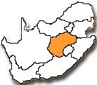
The Free State is one of the nine provinces of South Africa and is centrally located. It represents 10.6% of the total land area of the country. It boasts wide horizons, blue skies, mountains and goldfields. The province covers an area of 129 464 km2 and is roughly the size of Nicaragua. In 2011, the province had a population of 2.7 million with four district municipalities and one metropolitan municipality. The Free State is situated on the flat, boundless plains in the centre of South Africa. It borders most of the other provinces, the exceptions being Limpopo and the Western Cape. To the east, it has an international boundary with Lesotho nestling in the hollow of its beanlike shape, and the escarpment separates it from the Eastern Cape and KwaZulu-Natal.
The Orange and Vaal rivers form the southern, western and most of the northern border and the last section of the north-eastern boundary is formed by the Klip River. The western part of the Free State consists of plains, with pans as primary hydrological feature. The eastern part is mountainous. The Maluti Mountains along the border are connected to the Drakensberg on the border with KwaZulu-Natal. The province consists mainly of grasslands with some Karoo vegetation in the south.
Climate
Almost uniformly at about 1,300m above sea level, the Free State climate is typical of the interior plateau with rain falling in summer, cold winters and of sunshine. Almost all precipitation falls in the summer months, with aridity increasing towards the west. Frost occurs throughout the region usually from May to early September in the west and up to early October in the east. To the north, the Vaal irrigation area nourishes the small assortment of farming towns below it, and the hue of the Free State countryside is often green.
Areas in the east experience frequent snowfalls in winter, especially on the higher ranges, whilst the west can be extremely hot in summer. The south brings hot, dry summer days and long, cold winter nights. This semi-desert area also brings fluctuations of temperature from day to night. The west is warm and cold in equal measure, its inhabitants making use of the many man-made water recreation facilities to endure the heat as much as using heating facilities in winter’s low temperatures.
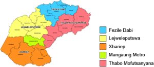
Regions
TheFezile Dabi District is an important agricultural production area, mainly maize. The Vaal Dam is the main source of water and offers a wide variety of leisure facilities. Other attractions include the Vredefort Dome, which is the third largest meteorite site in the world, and San paintings. Sasolburg is the location of the country’s largest chemical and synthetic fuel plant.
The Lejweleputswa District boasts goldfields and it is a major agricultural area. The district forms part of the larger Witwatersrand basin. The first gold was discovered in the early 1940s. Bothaville is one of the important maize centres in the country. The annual National Maize Production Organisation festival attracts more than 70 000 visitors and is the second largest private show in the world.
TheMangaung Metropolitan Municipality contains the largest population and comprises mainly of open grassland, with mountains in the most eastern region. The main urban centre is Bloemfontein. The city is the trade and administrative hub of the Free State and boasts the provincial government and the seat of the Appeal Court of South Africa. It also has a rich history, which includes the establishment of the African National Congress in 1912 and the National Party in 1914.
The Thabo Mofutsanyana District borders Lesotho to the east and has beautiful hills and fruit farms. The district is one of the most important tourism destinations due to spectacular scenic beauty of the Drakensberg and Maluti mountain ranges. Other attractions include the Golden Gate Highland Park, the annual cherry festival at Ficksburg, a Basotho cultural village in Maluti-a-Phofung, and Khoisan rock paintings.
The Xhariep District is located in the south-west of the province and is a semi-arid area with extensive farming, mainly sheep. The district comprises open grasslands with small wide dispersed towns. The Xhariep Dam is one of the tourists’ attractions. It offers a variety of leisure facilities.
Tourism
The Free State lies at the heart of the country. The province disposes of inter alia 14 nature reserves with varying facilities; four large holiday resorts; 12 state dams with banks totalling some 760 km; numerous sports and outdoor opportunities; nine restored battlefields; some 12 000 tourist beds and a booming guesthouse industry. Each region offers its own unique tourism attractions;
Mangaung
-
- Phillip Sanders and Maselspoort resorts near Bloemfontein
-
- Botanical Gardens, Naval Hill and Franklin Game Reserve
-
- Bloemfontein Zoo
-
- National Museum – huge collection of fossils and archaeological discoveries
-
- Women’s Memorial Monument
-
- Anglo-Boer War Museum
-
- SA Military Museum
-
- Freshford House Museum
-
- Waaihoek precinct, founding venue of the ANC
-
- Digareteneng (Place of curtains), built to coincide with the visit of King George V in 1952
-
- Maphikela House has been declared as a national monument and named after Mr Thomas Maphikela who was the first Secretary-General of the ANC
-
- Dr Sebe James Moroka House historical site (Thaba Nchu)
-
- Sand Du Plessis Theatre
-
- Loch Logan Waterfront
-
- Mimosa Mall Shopping Complex
-
- Oliewenhuis Art Gallery
-
- President Brand Street -housing inter alia Appeal Court, Free State Legislature, Gen. CR de Wet Statue, City Hall, Afrikaans Literature Museum
Fezile Dabi District
-
- Vredefort Dome World Heritage Site The Vredefort Dome World Heritage Site, declared a heritage site by UNESCO in 2005, came about in a matter of minutes an estimated 2 billion years ago when an asteroid that hit the earth, with the resultant rock formation today mainly between Parys, Vredefort and an adjacent part of North West Province spanning some 10 km in diameter. As such it is the largest known impact structure on earth.
-
- Eco-tourism at the Ghoya Africa conservancy situated on the R34 ± 12 km south of Heilbron en route to Edenville and the Francolin Creek Conservancy situated approximately 30 km east of Heilbron
-
- Two luxurious golf estates, private game ranches and nature reserves in the Parys region
-
- Deneysville at the Vaal Dam, hosts the biggest annual inland regatta, the Round the Island Race – on the 300 km² sprawling Vaal Dam.
Lejweleputswa District
-
- Aventura Aldam Holiday Resort and Willem Pretorius Game Reserve
-
- NAMPO Harvest Farm near Bothaville
-
- Golden Arts & Crafts Scramble at Hennenman and Virginia
-
- Aco tractor factory near Hoopstad
-
- Voortrekker Monument at Winburg
-
- Gold Museum in the Welkom Library
-
- Underground mine tours
-
- Phakisa Racetrack
-
- Folk Dancing Monument at Boshof
Thabo Mofutsanyane District
-
- Golden Gate National Highlands Park near Bethlehem
-
- Basotho Cultural Village at QwaQwa
-
- Seekoeivlei Nature Reserve near Memel constitutes a wetland with RAMSAR status is a bird-watching mecca
-
- Wolhuterskop Nature Reserve in Bethlehem
-
- Sterkfontein Dam
-
- Titanic Rock at the northern entrance of Clarens
-
- Bushman rock art at 27 farms near Fouriesburg
-
- Korannaberg Hiking Trail at Excelsior
-
- Mountain bike trails at Marquard
-
- Claerhout Art Gallery at Tweespruit
-
- Cherry Festival annually in November at Ficksburg
Xhariep District
-
- Gariep Dam and resort
-
- Annual Equestrian Endurance event at Fauresmith
-
- Railroad tracks running through the centre of Fauresmith
-
- Landzicht Wine Cellar at Jacobsdal
-
- Open Mine Museum and mining hole at Jagersfontein
-
- Open Mine Museum at Koffiefontein
-
- Transgariep Museum and Laurens van der Post Memorial at Philippolis
-
- The ‘Little Gallery’ at Smithfield
-
- Gariep Dam
-
- The ‘Eye’ of Zastron
-
- DH Steyn bridge near Bethulie